Webmapping and massive statistical data, a democratization story

Etienne Côme, @comeetie@mapstodon.space, FOSSDEM 2023

3/2/23

@comeetie

Researcher Gustave Eiffel University COSYS/GRETTIA
Stats, Data, Visualisation, Carto, Transports,…
R,JS,Python,Cpp,…

Francepixels, some context

Going back in 2014 !

Massive Grided statistical data

  • derived from tax sheets
  • 200m x 200m pixels
  • limit of the statistical secret (11 households)

Some context

open data but :

  • heavy files with tricky file formats and projection problems
  • only usable with pain
  • on dedicated software mapinfo / arcgis / qgis

An opportunity

Webmapping stack developped around the OSM project

\(\Rightarrow\) would allow to renew the data diffusion/visualiation approaches

An opportunity

Not the only one to see this opportunity

Oliver O’Brien did a quite similar proposal in the Uk in 2015 with data-shine

Technical details and choices

At that time vector tiles were slowly comming

\(\Rightarrow\) Massive advantage for statistical data

Francepixels, Technical details and choices

Tool-chain :

  • R to process the data and export geojson vector tiles
  • leaflet for raster tiles
  • d3 hook to render “vectors tiles” on canvas
  • invisible canvas tiles for interactivivity
  • details matter (color scales/map background/labels)

try it, still usable

MAUP and multiscale aggregation

The modifiable areal unit problem (MAUP) is a statistical bias that occurs when you aggregate point data.

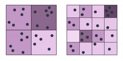
see, https://gisgeography.com/maup-modifiable-areal-unit-problem/

MAUP and multiscale aggregation

The modifiable areal unit problem (MAUP) is a statistical bias that occurs when you aggregate point data.

\(\rightarrow\) try aggregating the raw data at different scales and link them with zoom levels

solve two problems :

  • vector tiles sizes !! we need to keep them small
  • MAUP !! we want to explore several aggregation scales

Feedbacks and users

  • INSEE
  • Journalists, on specific topics eg. segregation and school
  • Urbanists for territorial diagnosis
  • Transportation researchers
  • Grided data user
  • Curious people …

Francepixels, evolutions

Vector tiles have since become a mature technology

and are no widely available

Francepixels, evolutions

A lot easier now :

Francepixels successors

Thanks

Questions ? Feedback